Rain could offer some relief to Oregonians, thousands of whom have been evacuated due to wildfires, and help firefighters suppress the existing fires scorching the state.
The storm front rolling in Thursday evening is expected to dump moisture west of the Cascades.
Doug Grafe, the chief of fire protection for the Oregon Department of Forestry, said the moisture will be hitting an ideal area.
“If I could script it, that’s exactly where I would [put it],” Grafe said, calling it “good news for Oregon.”
Grafe did warn that the winds could increase and, if the moisture doesn’t hit the burning area first, those winds could be problematic and test any fire containment lines firefighters have established.
“For the next 24 hours, we’re expecting some challenges with the weather,” Grafe said. “The storm front does bring favorable moisture, however, there are some downsides and it’s those winds and it depends on where the winds land.”
Firefighters have made significant progress on wildfires in recent days.
Grafe said the fires fully under control now include the Echo Mountain Fire near Lincoln City, the Powerline Fire near Gaston, the Chehalem Fire near Newberg and the Almeda Fire in southern Oregon, near Ashland and Medford.
There are still 10 large fires burning in the state.
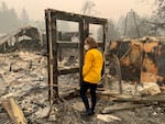
Countless homes and businesses have been destroyed in the fires that have burned about 1 million acres in the state.
Andrew Phelps, with the Oregon Office of Emergency Management, said the official death toll remains at eight people. Thousands of homes are still being assessed, he said. More than 2,000 people are staying in hotels or motels across the state, with 130 people staying in traditional shelters and another 875 staying in RVs or other types of shelter.
Kris Strickler, director of the Oregon Department of Transportation, said more than 240 miles of state roadways are closed.
The air quality is expected to improve in the coming days, according to Gabriela Goldfarb, with the Oregon Health Authority. She said by Friday most Oregonians will be breathing cleaner air.
Related: Incoming rain could improve Oregon's air quality
Flash flood warnings bring landslide risks to burn areas
The National Weather Service issued a flash flood warning Thursday for burned parts of the Beachie Creek and Holiday Farm fires east of Oregon’s Willamette Valley.
The alert said to expect possible debris flows, which are surface landslides that occur after severe fires. They move enough to catch a car, and can carry boulders and logs downhill at terrifying speeds.
Oregon Department of Transportation senior geologist Michael Zimmerman spent the last two days driving the length of Highway 224, which cuts through the heart of the Riverside Fire in Clackamas County. His job is to analyze landslide risk. He was hopeful going in: ODOT had done a lot of work along highway 224, putting up fences and nets to catch falling rocks. But as he drove through the burned area, that hope dwindled.
“It’s worse than I feared. It really is,” Zimmerman said. All the underbrush, all the vegetation that normally holds soil in place, had burned to ash.
But that doesn’t mean that the predicted debris flows will actually occur. Almost all the research on post-fire debris flows has been done in California and Colorado: ecosystems that are very different from the ones in Oregon’s Cascade Mountain Range.
Oregon’s 2017 Eagle Creek Fire in the Columbia River Gorge is a useful reference, said Josh Roering, a geologist at the University of Oregon.
“The weather service issued a similar alert [two months] after the Eagle Creek Fire,” Roering said. Although small landslides closed Interstate 84 and parts of the historic Columbia River Highway, “No flows ever came.”
Roering thinks the steep topography of the gorge stopped water from accumulating and flooding the area. “But we really don’t know. This area doesn’t burn enough for us to understand post-fire soil behavior,” Roering said.
For now, fire crews are keeping a close eye on the weather and playing it safe. If the predicted thunderstorms cause enough rain to start a debris flow, the firefighters plan to be long gone before the mud and water come.
Red Cross closes operations at Oregon Convention Center evacuation shelter
The Red Cross shelter operating at the Oregon Convention Center in Portland for people who evacuated from Clackamas County and other area wildfires closed its operations Wednesday night.

Emily Girard of the American Red Cross speaks with Sue Barnes at an American Red Cross shelter at the Oregon Convention Center in Portland, Ore., on Monday, Sept. 14, 2020, after Barnes evacuated because of wildfires burning throughout the region.
Scott Dalton
The Red Cross moved people staying at the evacuation shelter to a nearby Portland motel, according to Multnomah County. The Red Cross said anyone needing access to the Red Cross Shelter should contact Red Cross at 877-272-7337 or visit the Red Cross Disaster Shelters locator.
Multnomah County’s Joint Office of Homeless Services said it will continue providing shelter for people experiencing homelessness, both at the Oregon Convention Center and the Charles Jordan Community Center.
Oregon Gov. Kate Brown visits Beachie Creek Fire
Gov. Kate Brown visited the command center for one of Oregon’s most destructive and deadly fires of a wildfire season that has become historic in its disastrous effects over the last 10 days. Brown appeared in a video alongside three top officials on the firefighting effort: State Fire Marshal Marianna Ruiz-Temple, Oregon Department of Forestry Director Peter Doherty and ODF Fire Chief Doug Grafe.
Oregon Gov. Kate Brown tours an area damaged by the Beachie Creek Fire, Sept. 16 2020. The Beachie Creek Fire swept through the Santiam Canyon area.
Office of Gov. Kate Brown
“The heroic efforts of Oregonians, of first responders from all over the region, saved lives, and I’m incredibly grateful for their efforts,” the governor said in a recorded appearance at the command center for the Beachie Creek Fire.
“We still have a lot of work to do as we move into recovery mode.”
In a press release after the visit, the governor’s office said Brown met with members of the National Guard and visited the command post in the community of Gates, which burned from the Beachie Creek Fire, as firefighters were attempting to control the blaze.
By Wednesday afternoon, the Beachie Creek Fire — also known as the Santiam Fire — had burned over 190,000 acres and was 20% contained. It’s responsible for at least four deaths and destroyed 1,288 structures, including 470 homes. Over 14,000 homes across three counties remain under Level 3 “Go Now” evacuation orders, with an estimated 36,000 people currently displaced.
Related: Fire officials say downed power lines played a role in Beachie Creek Fire
Fire resources and information
These online tools offer up-to-the-minute emergency information on wildfires, evacuations and air quality in the Pacific Northwest:
- The EPA’s Air Quality Index: Hourly updates of local air quality readings.
- BlueSky Canada has an interactive map of wildfire smoke forecasts across the Pacific Northwest.
- Northwest fires and evacuations: Oregon’s RAPTOR Map shows wildfires across the U.S. West and evacuation zones within the state.
- Major Oregon and Washington fires: The Northwest Interagency Coordination Center shares this map of major fires in the Pacific Northwest
- Here are some practical tips — including a packing list — on how to prepare for a wildfire evacuation.
- PublicAlerts.org provides links to sign up for emergency phone and email alerts across the Portland-Vancouver metro area.
- Outside the greater Portland metro area, alerts are handled by local governments. Search “Emergency Alerts” and your county’s name to find a link.
Large fire summary:
Archie Creek Fire: The fire burning in Douglas County is more than 128,000 acres in size and 20% contained as of Thursday morning. The land burned by the Archie Creek Fire is roughly split between private property and land owned by the U.S. Forest Service and Bureau of Land Management.
Beachie Creek Fire: More than 190,000 acres have been burned by the Beachie Creek Fire as of Thursday morning. It has killed at least four people and destroyed 1,288 structures, and damaged another 134, according to InciWeb, an online clearinghouse for firefighter coordination. The fire is considered 20% contained as of Thursday morning, but more than 5,000 structures remain within the Level 3 “Go Now” evacuation zone.
Holiday Farm Fire: The blaze responsible for burning communities near the McKenzie River has burned more than 170,000 acres and is 10% contained as of Thursday afternoon. Though the official size of the fire increased by 3,000 acres, much of that is due to better data, not fire growth. More than 500 structures have been destroyed through the area. Thunderstorms this evening and through the weekend could bring gusty winds, rain and even hail to the area.
Riverside Fire: Burning just north of the Beachie Creek Fire, the Riverside Fire is estimated at nearly 138,000 acres in size and is 6% contained as of Thursday afternoon. In a Thursday update, the fire’s assigned meteorologist wrote that the area is likely to receive a quarter- to a half-inch of rain as unsettled weather brings thunderstorms to the area, with the potential for up to an inch of precipitation.
Federal declaration opens stream of disaster unemployment funds
Among the resources that the White House’s disaster declaration offers to Oregon is a new funding stream to benefit people whose jobs went up in flames from the wildfires still burning in parts of the state. The Oregon Employment Department announced Wednesday that people who’ve become unemployed as a result of the state’s catastrophic wildfires will soon get support from Disaster Unemployment Assistance.
Now with so many programs — regular unemployment insurance, pandemic unemployment assistance, extended benefits, as well as pandemic emergency unemployment compensation — Oregon Employment Director David Gerstenfeld acknowledged it can be hard for out-of-work Oregonians to know which program they’ll fall under. Gerstenfeld said the agency intends to ensure people who need help will be connected to the program for which they’re eligible.
Related: Oregonians who lost jobs in wildfire can seek disaster assistance